
Coastal Mendocino Sightseeing
Due to COVID-19, it’s recommended that you check website information to review any changes or conditions that may effect your visit.
Coastal Mendocino Sightseeing

Stretching north to south, from Westport to Gualala, the coastal towns of Westport, Fort Bragg, Mendocino, Little River, Albion, Elk, Manchester, Point Arena, Anchor Bay and Gualala offer spectacular scenery, outstanding recreational opportunities, fine dining and superb lodgings.
Westport

The beautiful, laid-back village of Westport perches on bluffs 80 feet above sea level, approximately 28 miles west of Hwy 101 and 16 miles north of Fort Bragg. During the redwood lumber boom of the 19th century, for a while it was the fastest growing coastal town north of San Francisco. It served as a busy commercial shipping harbor, with two massive wharves loading not only lumber but also wool, oats, tanbark, shingles and railroad ties into schooners bound for San Francisco. At its peak Westport boasted 14 saloons. These days, residents settle there seeking a strong sense of community and an escape from the harried pace of city life. Visitors find a charming windswept seaside village with a bluff-top park suitable for picnics, volleyball games and weddings where a bustling shipping yard once sat.
Fort Bragg

Originally established as a military outpost overseeing the Mendocino Indian Reservation in 1857, by 1869 small lumber mills and ranches had become the area’s dominant features. The earthquake of 1906, which leveled much of Fort Bragg, also brought prosperity to the town in its wake, as its mills provided much of the lumber used to rebuild San Francisco. Today, Fort Bragg is the largest city on the Mendocino Coast. Much of Fort Bragg’s history can be viewed at the Guest House Museum, located on the corner of Main (Hwy 1) and Laurel Sts. Built for the Fort Bragg Redwood Company in the 19th Century, the building later became the Union Lumber Company guest house, and now houses artifacts, photos and exhibits from the town’s early days.
Noyo Harbor, on the south end of town, is a working port with a commercial fishing fleet, charter boats, fish markets and processing plants, as well as several seafood restaurants. The harbor is also a haven for local seals and sea lions.
Things To Do
- Enjoy excellent restaurants, lodging, retail store and antique shops.
- Beaches are nearby for beachcombing, picnicking and surf fishing.
- Explore Noyo Harbor.
- Kayak, paddleboard or charter a boat for whale-watching or fishing, or both, November through April.
- MacKerricher State Park has numerous campsites and day use areas, as well as a raised wooden walkway that leads to a seal observation point overlooking a secluded cove. The walkway is wheelchair accessible. The park also features a small lake and miles of unspoiled coastline with outstanding tide pools.
- The Skunk Train takes passengers on a scenic tour of the redwood forests east of Fort Bragg along the Noyo River.
- Mendocino Coast Botanical Gardens, two miles south of the center of Fort Bragg, contains 47 acres of flowers, trees and shrubs with winding trails throughout.
- Visit Fort Bragg Skate Park at the C.V. Starr Community Center, 300 South Lincoln Street.
Noyo Harbor

One of the West Coast’s most scenic harbors, Noyo Harbor is the perfect place to start your day of adventure on land or on the high seas. Highway 1 passes over the harbor along the Noyo Bridge; the harbor itself is located at the mouth of the Noyo River at the southern end of Fort Bragg. Here the towering redwoods sprawl to the edge of the continent, stopping just short of spilling into the vast Pacific Ocean.
Gorgeous views and warm hospitality make Noyo Harbor a great place to meet the ocean from the land. The harbor is home to abundant wildlife, extraordinary fishing and whale-watching opportunities, and world-class lodging and dining. It is a must-experience destination for outdoor recreation.
Communing with nature is a way of life in Noyo Harbor. Harbor seals, sea lions and even river otters bask in the sun, play, and poke their smooth looking heads out of the water, all around the bay. Waterfowl, including osprey, cormorants, pelicans and gulls, patrol the waters looking for their next edible opportunity. Nature lovers have plenty to marvel at, with the wide variety of wildlife that makes the harbor home.
Fishing Charters
The harbor offers excellent sport-fishing opportunities; a local guide can draw from firsthand experience on these waters, supply the proper gear, and show you how to catch that monster fish. Charters are available from the harbor and can accommodate almost any ocean fishing need. The harbor and surrounding coastal areas are teeming with fish including rockfish, lingcod, halibut and tuna, and are some of the best places on the West Coast to catch Chinook salmon.
Kayaking
Touch, taste and smell the harbor at water level from a kayak. Visitors can bring their own kayaks, rent them in the area, or employ local outfitters for guided tours. Kayaking in the harbor is a great experience for the beginner, the expert, or anyone at any skill level in between. When the tide is right the beginner can paddle down the Noyo River to enter the ocean, taking in the views. For the more experienced, or if kayaking with a guide, the harbor has spectacular sea caves to explore, abalone diving and even fishing from the kayak. Whether sightseeing, sport kayaking or fishing, kayaking in Noyo Harbor is a healthy, delightful way to spend a day, and a fun way to connect with family and friends.
Dining & Lodging
Enjoy the ocean view, taste the catch of the day and sip a local Mendocino wine. The harbor has a variety of dining options to choose from, the food is fresh and the atmosphere and views are free. Several lodging options are available on the harbor; choose from ocean view rental homes, enjoy the personal touch at a nearby bed and breakfast, or camp at the mouth of the Noyo River. Whatever your plan or price range, you can wake to an ocean view or watch the sun set over the Pacific Ocean.
Noyo Headlands Park

photo by Ron Levalley, LevalleyPhoto.com
Fort Bragg’s newest park is situated atop the bluffs overlooking Fort Bragg’s dramatic, rocky Pacific shore. Its northern section was opened in 2015, extending the Pacific Coast Trail from Pudding Creek at the northern end of town down to Otsuchi Point. It includes a stairway down the bluffs to Glass Beach.
In 2016 the southern section of the park was opened, stretching from Noyo Harbor to the Crow’s Nest, the charming visitors center run by the Noyo Center for Marine Science. In early 2018, city officials completed the center portion, adding 1.3 miles of new trail. With the addition of the central trail link, the park totals about 106 acres, and the Pacific Coast Trail runs without interruption all the way through Fort Bragg, connecting north of town across the Pudding Creek Trestle to MacKerricher Park, and south across the Noyo River Bridge to Pomo Bluffs Park, for a total distance of 7.5 miles.
The trail provides the first public access to Fort Bragg’s rocky coast since the 1800s. Views are spectacular, and Noyo Headlands Park has already gained the enviable reputation of being one of the best places anywhere to view stunning sunsets. Dogs are allowed but must be kept on leash.
The park was reclaimed from an industrial mill site owned by Georgia-Pacific. Much of the site was covered with asphalt, which was removed, and the entire area was restored to its natural state. The project has cost millions of dollars, provided largely by Prop. 84 funds and the California Coastal Conservancy.
WHERE: Access to the park is via Elm Street at the north end, and Cypress Street at the south. Parking and admission are free, and the park is open 24 hours a day.
MORE INFO:
Fort Bragg Dept. of Public Works, 707-961-2824;
Noyo Center for Marine Science, 707-733-NOYO (6696), NoyoCenter.org
The Crow’s Nest Interpretive Center

Follow the gorgeous Fort Bragg Coastal Trail to the Crow’s Nest Interpretive Center, and explore the dynamic exhibits offered by the Noyo Center for Marine Science. Staffed by a dedicated group of volunteer ocean stewards, the Center is a science hub located on the southern portion of the Coastal Trail with closest access through the Cypress Street entrance. It introduces visitors to an array of marine science themes, and informs them on how we can all have an impact on ocean conservation. The Crow’s Nest is also home to rotating marine science exhibits, an aquarium filled with local intertidal creatures, and four fully articulated marine mammal skeletons. A wide selection of marine science related videos is available for view. With its stunning view of the Pacific, the deck of the Crow’s Nest is a perfect place to watch for whales and other marine life using the Center’s telescopes.
The Noyo Center for Marine Science’s mission is to advance ocean conservation through education, exploration and experience. Come be a part of it today! Open daily from Thursday to Monday, closed Tuesdays and Wednesdays. Call or go online for seasonal hours. Admission is free.
Another exhibit to see is the Center’s 26-foot Killer Whale skeleton on display for free at CV Starr Community Center at 300 S. Lincoln St., Fort Bragg.
WHERE: South Fort Bragg Coastal Trail near the Cypress Street entrance.
MORE INFO: Noyo Center for Marine Science, 707-733-NOYO (6696), NoyoCenter.org
MacKerricher State Park

MacKerricher State Park offers miles of magnificent rocky coastline, beaches, dunes, bluffs and headlands that give way to forests, seasonal streams, grasslands, and a lake. Some of California’s richest tide pools form during low tide along the shore near Laguna Point, where offshore rocks attract black oystercatchers and provide a rookery for harbor seals.
The park encompasses nearly 2300 acres, over 450 of which are designated “underwater park,” preserving some
of the best and most unique of California’s natural underwater ecosystems. Inglenook Fen, the last remaining coastal fen in California, supports salamanders, rare insects and shorebirds. Waterfowl and wading birds frequent Lake Cleone and Mill Creek; in fact, more than 100 bird species have been observed in MacKerricher State Park. A convenient boardwalk wanders past Lake Cleone, and another, the wheelchair-accessible Laguna Point Boardwalk along the beach, provides sweeping vistas of the coast and five overlook platforms for whale- and harbor seal-watching. The historic Haul Road runs through much of the park and is great for hiking and bicycling. Most of it is wheelchair-accessible as well. The park also offers opportunities for camping, horseback riding, fishing and abalone-diving. Glass Beach, at the southern end of the park, is noted for brightly colored, wave-polished glass pebbles, remnants of broken glass dumped there between 1906 and 1967.
MORE INFO: 707-964-8898, www.parks.ca.gov/?page_id=436
C.V. Starr Community Center Pool & More

Much more than a swimming pool, fitness center, community center and outdoor activity area combined, the C.V. Starr Community Center offers people of all ages a wealth of wonderful, exciting things to do and magnificent facilities to do them in. The physical infrastructure is a 4-acre campus that hosts an off-leash dog park, a 10,000 square foot skate park, sun deck, BBQ and picnic area, two petanque (an ancient Roman game) courts, and a 43,000 square foot aquatics and fitness facility. Inside that facility they have a full waterpark-style pool complete with a 146 foot water slide, zero depth entry warm water leisure pool, lazy river, eight lane lap pool and a 1 meter diving board. In addition to the pools there are two group exercise studios, a wellness center with a full range of weight and cardio equipment, and multipurpose rooms for meetings and an incredible variety of enrichment classes for everyone from pre-schoolers to senior citizens. Visit their website for information on hours, fees and class schedules.
WHERE: 300 S. Lincoln St., Fort Bragg
MORE INFO: 707-964-9446, MendoCoastRec.org
The Historic Skunk Train,
Fort Bragg Depot

If you don’t happen to own a time machine, the next best thing would probably be a trip on Mendocino County’s famous Skunk Train. From the restored historic rail cars to the dramatic views of majestic redwood forests, scenic upland meadows, and the pristine mountain waters of Northern California, what you will experience is largely unchanged from the way things were in the late 1800s.
The Skunk Train offers a wide selection of rides, including half-day trips, overnight trips, a sunset BBQ excursion, trips that include camping or kayaking, and even — if you make your reservations enough in advance — a chance to ride in the engine’s cab with the engineer and the fireman! There are also special event trips, some of them holiday-themed. Excursions begin in Willits or Fort Bragg, and depending on which trip you choose, will either bring you back to your starting point or all the way to the end of the line. Departing from Fort Bragg, the first few miles are along the Pudding Creek estuary, where you might sight blue heron, egrets, osprey, ducks, and the occasional lounging turtle. After passing through Tunnel No. 1, the Skunk Train snakes its way along the Noyo River, zigzagging through the redwood-thick Noyo River Canyon. If you continue past Northspur (the midway point), your train will descend the Eastern slope of the California Coast Range, cutting through it at Tunnel No. 2 (Summit); this is the mountainous part of the railroad line, in which 8.5 miles of track cover a straight-line distance of less than one mile.
WHERE: Skunk Train Fort Bragg Depot, foot of Laurel St., Fort Bragg.
MORE INFO: 707-964-6371, SkunkTrain.com
Mendocino Coast
Botanical Gardens

Lose yourself for an hour — or all day — at Mendocino Coast Botanical Gardens, one of only a handful of public gardens with ocean frontage. The #2 garden on Sunset magazine’s list of top public gardens, these magical 47 acres encompass manicured gardens, fern-ringed ponds, intimate pocket gardens, coastal pine forests, and wildflower-strewn bluffs at ocean’s edge. Enjoy a picnic on a lush meadow lawn, visit their expanded organic demonstration Vegetable Garden, or plan a celebration in a rustic gazebo encircled by the glory of late-summer dahlias.
The mild maritime climate of the Mendocino Coast offers ideal growing conditions for rhododendrons, heaths and heathers, heritage roses, succulents, conifers, and so much more. The Gardens provides habitat for more than 150 species of birds that live in or visit the Gardens yearly, and the Cliff House provides an indoor vantage for watching winter and spring grey whale migrations. This “garden for all seasons” is a place to enjoy a retreat from the world, any time of year. Spring brings a profusion of bulbs and stunning rhododendrons. Summer finds the Perennial Garden in full bloom and the Dahlia collection coming into a riot of color. In fall, an abundance of mushrooms burst forth (not for picking or consumption) — a mycologist’s paradise! Quiet contemplation can be found while wandering the fern-lined creeks in the soft light of winter.
The Gardens is for all ages; come see what makes the garden special. There is no admission fee to visit the Store, Nursery or Café. Picnickers are welcome, and the Gardens is dog-friendly.
WHERE: 18220 N. Hwy 1, Fort Bragg
MORE INFO: For hours, admission information, and a complete listing of special events and workshops, visit GardenByTheSea.org or call 707-964-4352 ext. 16.
Annual Whale Migration
& Whale Festivals

The annual migration of California gray whales takes them from their feeding grounds in the cold waters of the Bering Sea near Alaska to the warm waters off Baja California, Mexico, and back. Their young, called calves, are born in the protected lagoons of western Baja, and do not begin their trek northwards until they are about a month old. Unlike other whale species, California grays stay fairly close to the coast, often within a few hundred yards of shore. This means that twice a year (from November to February going south, and from February to June going north), visitors can observe whales from atop the Mendocino headlands.
To celebrate this happy occurrence, three festivals in honor of the confluence of whales and all things Mendocino have sprung up on successive weekends in March: the Mendocino Whale Festival, the Little River Whale Festival and the Fort Bragg Whale Festival. Activities include food, beer and wine-tasting, art exhibits, whale-related educational programs, nature walks, and whale-watching from the headlands, from chartered boats and from kayaks, plus lots more. Don’t miss the fun!
WHERE: Mendocino Coast
MORE INFO: Mendocino Coast Whale Festivals, 707-961-6300, MendoWhale.com;
707-937-4700, MendoParks.org/whale-festival
Mendocino Village

A trip to Northern California would not be complete without a stop in the quaint and historic Village of Mendocino. This lovely town, which sits on rugged bluffs overlooking the Pacific Ocean, features dozens of shops, art galleries, bed-and-breakfast inns and is host to several special events every year, including the Mendocino Whale Festival in March and the Mendocino Music Festival in July.
The beauty of the town is what first impresses visitors. Perched on bluffs painted with wildflowers and overlooking the Pacific Ocean, some of the homes and shops from the 1850s still stand today, although most of the structures are Victorians from the second half of the 19th century. There are also examples of New England Salt Box, Gothic Revival, Italianate and vernacular (defined by local style) architecture. Many of these historic buildings are now on the National Register of Historic Places.
In July of 1850 the Frolic, a two-masted clipper ship bound for San Francisco from China, shipwrecked a little north of present-day Mendocino. A salvage crew was unable to recover the cargo, but did discover vast stands of old-growth redwood trees. A mill was built, and the village of Mendocino grew up around it. Pioneers “came ’round the horn” in the mid-19th century to be a part of the town’s lumber boom that resulted from the Gold Rush. San Francisco was a booming city in need of building materials, and harvesting coastal redwoods abundant around Mendocino provided a source of prosperity for people in the small town.
Visitors will be delighted in and around this picturesque town. The area offers deep-sea fishing, whale-watching, canoeing, kayaking, abalone diving, surfing, hiking, biking and horseback riding. Trails lead from the headlands down to beaches where visitors can search for seashells or explore the numerous tide pools. However, beachcombers and hikers should always keep an eye on the ocean. Large “sneaker waves” are common, and can sweep unsuspecting hikers off the rocks and out to sea.
Be sure to stop in at the Ford House Museum and Visitor Center, open daily from 11am to 4pm, where you can take a look at a model of what the town looked like almost a century ago. Also visit the Kelley House Museum to learn more about the history of this charming village. Kelley House Museum is open Friday through Monday 11am to 3pm Visitors can enjoy a Historic House and Building Tour that begins there every Saturday and Sunday at 11am, and lasts 1 1/2 hrs.
MORE INFO:
Ford House Museum, 735 Main St., Mendocino, 707-937-5397, MendoParks.org;
Kelley House Museum, 45007 Albion St., Mendocino, 707-937-5791, MendocinoHistory.org
Mendocino Headlands State Park

When visiting the town of Mendocino, take some time to see Mendocino Headlands State Park. The park surrounds the town on three sides with delightful expanses of land perched atop stunning bluffs. From there you can enjoy whale-watching in the winter, wildflowers in the spring, nesting seabirds in the summer and vivid color throughout autumn. Miles of trails wind along the cliffs, surprising the casual explorer with spectacular views of sea arches and hidden grottoes. Three miles of trails meander atop the rugged and majestic cliffs that line the coast. The park has a beach that is accessible from Hwy 1 or by trails down the bluffs, and offers excellent fishing and scuba diving opportunities.
WHERE: Surrounds the town of Mendocino on three sides.
MORE INFO: 707-937-5804, www.parks.ca.gov/?page_id=442
Russian Gulch State Park

This is a gem of a park, offering almost a mile and a half of ocean frontage with great beaches and tide pools, plus more than 10 miles of lush, forested hiking trails and plenty of horseback riding trails. You’ll find a beautiful picnic area perched on a cliff overlooking a dramatic cove; spacious, well-laid out campgrounds with bathrooms and hot showers; a 3-mile long paved bicycle trail; and a 36-foot high waterfall that’s one of the park’s star attractions. Another highlight is the Devil’s Punchbowl, sometimes referred to as “the blowhole,” a partially collapsed sea cave 200 feet from the water’s edge that offers a stunning view of churning, surging waves 60 feet below you. The beach offers swimming, tide pool exploring, kayaking, abalone diving and rock fishing. Russian Gulch Creek Canyon is heavily forested.
WHERE: 2 miles north of Mendocino on Hwy 1.
MORE INFO: 707-937-5804, www.parks.ca.gov/?page_id=432
Point Cabrillo Light Station
& Preserve

Construction of the Point Cabrillo Light Station began in 1908, and its lens, a British-build 3rd order Fresnel lens, was illuminated for the first time in June of 1909. The station operated under the U.S. Lighthouse Service and then the Coast Guard before being acquired by the California State Coastal Conservancy in 1991.
Today the light station and its grounds, along with 270 acres of undeveloped coastal bluffs and prairie, are part of the California State Parks system. The light station has been completely restored, and the Fresnel lens, which was decommissioned in 1973, has been refurbished and remounted. A beautiful lightkeeper’s house has been converted into a museum, set up the way it was in the early 1900s. The grounds are surrounded by ocean and headlands vistas in every direction.
The Point Cabrillo wildlife area has some of the most beautiful scenery on the West Coast. Deer roam the headlands, harbor seals play in the coves, black oystercatchers grace the rocky shorelines, while songbirds, squirrels, weasels and rabbits frolic along our bluffs. During the whale migration season you may even see some of the estimated 18,000 gray whales that migrate from Mexico to Alaska every spring.
Inside the lighthouse and fog signal building is a gift shop and museum that is open 365 days a year. Shop for unique gifts and donate to the nonprofit that manages this historic property. The gift shop is staffed by volunteer docents, and is open from 11am to 4pm every day. The park is open from sunrise to sunset.
WHERE: Midway between Mendocino and Fort Bragg, off Hwy 1 on Point Cabrillo Drive. Follow signs.
MORE INFO: 707-937-6123, PointCabrillo.org
Caspar Headlands State Reserve & State Beach

The title of “State Reserve” in California is only given to areas of land that have outstanding or unusual natural or scenic value. Caspar Headlands State Reserve certainly lives up to this title. Located about 4 miles north of Mendocino off Hwy 1, this 3-acre reserve is located just south of the town of Caspar and sits atop one of California’s most strikingly beautiful coastal bluffs. The reserve is characterized by sculpted rock formations and spectacular cliffs that provide dazzling views. It is also home to a magnificent array of wildflowers.
In order to gain access to the reserve, you will have to obtain a free entry permit from the Mendocino Sector Office, located across from Russian Gulch State Park.
WHERE: South on Point Cabrillo Rd., past the RV campground, turn right on Caspar Dr. to Headlands Dr. Parking is outside the reserve on Caspar Dr.
MORE INFO: 707-937-5804, www.parks.ca.gov/?page_id=444
Nestled adjacent to Caspar Headlands State Reserve just north of Mendocino, Caspar Headlands State Beach offers swimming, boating, fishing and other popular beach activities. From it you can enjoy panoramic views of the Pacific Ocean meeting the headlands’ rugged cliffs and coastal bluffs. If you happen to arrive between November and June, you might get to see some California gray whales as they migrate. The headlands are among the most beautiful and awe-inspiring locations on the West Coast, and are well worth the trip. The weather can be changeable, so it’s a good idea to wear layered clothing.
WHERE: 2 miles north of Russian Gulch on the coast access road (Point Cabrillo Dr.) From the north, it is 1 mile south of the turnoff at milepost 54.71 on Hwy 1.
MORE INFO: 707-937-5804, www.parks.ca.gov/?page_id=445
Little River & Van Damme State Park

Little River began life as a mill town. Its first lumber mill was built in 1864, and next to it arose the shipyard of Thomas Peterson, whose vessels won prizes for their design and craftsmanship, including first prize in San Francisco at the Fourth of July Regatta in 1876. On average, three prime trees were used to build each ship. The mill closed in 1893, then burned down in 1910.
Little River Cove offers one of the most popular beaches on the Mendocino Coast. The protected cove is a great place for water recreation, and many divers splash into its smooth waters in search of abalone and other underwater treasures.
The cove is also near the entrance to Van Damme State Park, one of the coast’s favorite parks. It offers beautiful hiking trails in the lush Fern Canyon trail system along the fern-carpeted floors of the Little River Canyon. You will feel like a giant in the Pygmy Forest with its mature cypress and pine trees that grow between 6 inches and 8 feet tall, or you might decide to follow your nose to skunk cabbage at the Cabbage Patch bog. Van Damme offers several camping options and year-round guided coastal kayak tours.
Besides hiking, you can also enjoy camping, fishing and abalone diving among other recreational activities at Van Damme State Park. It straddles Hwy 1 where Little River empties into a protected rocky bay that is very popular with divers and kayakers. The surf here is usually calm enough to allow launching boats and sea kayaks from the beach.
Daytime parking and picnicking at the beach are free. Most of the park’s 2069 acres lie east of the highway, up verdant Fern Canyon. The park offers beautiful and shady campsites, available on a first come, first served basis. A paved trail follows the Little River 2.5 miles up the lovely canyon, connecting with a dirt path that climbs to the Pygmy Forest. For the more adventuresome hiker, there is an extensive system of trails that meanders throughout the park over 10 breathtaking miles. Whether your stay is short or extended, you can always count on finding an unforgettable adventure at Van Damme State Park.
WHERE: 3 miles south of the town of Mendocino on Hwy 1.
MORE INFO: 707-937-5804, www.parks.ca.gov/?page_id=433
Jug Handle Ecological Staircase

It is likely that you will never experience anything quite like the Jug Handle State Natural Reserve’s Ecological Staircase. The “staircase” is a land formation (not a literal stairway) that stretches for 2.5 miles over five wave-cut terraces formed by glacial, sea and tectonic activity. Starting in the inter-tidal zone, it ascends through a series of areas that include prairie, pine forest and even a unique pygmy forest with knee-high trees.
The nonprofit Jug Handle Creek Farm and Nature Center acts as a private gateway to the area, and offers environmental education programs that are packed with fun and entertaining activities.
An educational brochure is available to explain the changing environments as you travel the 5-mile trail up the slope.
WHERE: Halfway between Fort Bragg and Mendocino on Hwy 1.
MORE INFO: www.parks.ca.gov/?page_id=441
Jug Handle Creek Farm and Nature Center, 707-964-4630, JugHandleCreekFarm.org
Albion

In 1853 Captain W.A. Richardson built the first lumber mill in the town of Albion, on the river flats below the high wooden trestle bridge that spans the Albion River. The ancient name for England was chosen for the town in memory of Sir Francis Drake landing in Northern California in 1579 and naming it “New Albion.”
Today Albion features restaurants, lodging, a fully equipped grocery store and deli, and other necessities for the traveler. The area around Albion is rich with sheltered coves that are excellent for tide-pooling, hiking and exploring. Albion Ridge Rd., which travels east of Hwy 1, will afford the traveler panoramic views of the area’s rolling hills as they slope down to the ocean. It is an excellent place to watch red-tailed hawks and, in winter, the migratory tundra swans on their way to the Garcia River, south of Albion.
Elk & Manchester

The Village of Elk, previously known as Greenwood, is a charming stop along the Northern California Coast. In this little town you’ll encounter stunning views of the shoreline and Pacific Ocean in a mesmerizing meeting of land, sea and sky, punctuated by waves breaking against picturesque rock formations known as sea stacks. On a coast celebrated for its scenic beauty, Elk is truly exceptional.
In the 1800s trappers and hunters found their way to the region in search of game. Britton Greenwood, the son of the famed tracker-explorer Caleb Greenwood, was the first to carve out a ranch there, which he named the Elk Ranch. A community grew up around the ranches and dairy farms, and soon small mills were established to process the spectacular old-growth redwood. In 1883 local businessman Lorenzo White purchased most of the land around Elk, erecting a large mill and building a railroad to serve it. At one point Elk supported a population of almost 1,000. At the turn of the century Elk was alive with hotels, dance halls, saloons and general stores. According to some accounts, in February of 1902 Jack London wrote his masterpiece, The Call of the Wild, while staying in the old White boarding house, today known as the Hospital House, across from Li Foo Gulch.
Manchester is a beautiful, tiny village with a population of about 200. Situated in an area of rich grazing land about 13 miles south of Elk, flocks of sheep and herds of cattle can be seen, adding a pastoral note to some of the most spectacular coastal scenery in the world. Nearby Manchester Beach State Park offers a beach, sand dunes, flat grasslands and more than three miles of shoreline.
Greenwood State Beach
Just south of the small town of Elk you’ll find picturesque Greenwood Creek State Beach. Here you can soak up the sun, go swimming or have a picnic lunch on the coast. It’s also a wonderful place to go for a stroll and watch the sunset any time of year.
Greenwood, the old name for Elk, was a lumber town in the late 1800s and early 1900s. Today the Greenwood State Beach Visitor Center, which used to be the Elk post office, houses a museum that includes artifacts from the lumber camps and period furniture that includes turn-of-the-century household appliances. There are also a magnificent mural of the old Greenwood wharf, and books and postcards for sale that cover a wide range of coastal subjects including Pomo Indian culture and local history. The Visitors Center is open on Saturdays and Sundays from 11am to 1pm from Memorial Day to Labor Day.
WHERE: Just south of Elk, about 15 miles north of Point Arena.
MORE INFO: 707-937-5804, www.parks.ca.gov/?page_id=447
Manchester State Park
Manchester State Park, with nearly 18,000 feet of ocean shoreline, offers a beach with an abundance of driftwood, sand dunes and rich grasslands. A beautiful sandy beach runs southward for about 5 miles towards Point Arena. Among its many attractions is the excellent steelhead fishing in its two streams, Brush Creek and Alder Creek. Please check with the Department of Fish and Wildlife at 530-225-2300 for seasonal closures and restrictions.
Manchester State Park is home to a wide variety of gorgeous coastal wildflowers and provides habitat for tundra swans and other wildlife. The San Andreas Fault runs into the ocean here. Much of the area is used for grazing sheep and cattle, lending a pastoral note to the local scenery. Temperatures tend to range between the low 50s and low 70s most of the time. It is usually windy and often rainy or foggy; wearing layered clothing is recommended. The park takes its name from the village of Manchester, located on Coast Hwy 1 about 7 miles north of Point Arena.
WHERE: The main park entrance is located at 44500 Kinney Ln. (off Hwy 1), 1/2 mile north of the town of Manchester.
MORE INFO: 707-937-5804, www.parks.ca.gov/?page_id=437
Point Arena

Located on the coast of southern Mendocino County about 130 miles north of San Francisco, Point Arena is one of the smallest incorporated cities in the state of California, with a population under 500, and also one of the most beautiful.
Surrounded by the Point Arena-Stornetta Public Lands (a recently designated unit of the California National Coastal Monument), the Point Arena Lighthouse (the tallest on the West Coast of the United States) and the Point Arena Public Fishing Pier in Point Arena Cove, the city and its surrounding area offer incredible natural beauty and a wide range of recreational activities. These latter include fishing, surfing, tide-pooling, whale-watching, sightseeing, fine dining and lodging, enjoying music and film, and taking jaunts to well-preserved historical structures. The Point itself is a land mass jutting out into the ocean, and the spot closest to Hawaii in the contiguous 48 states.
Point Arena Pier
at Arena Cove
Point Arena Cove is a popular destination for fishermen, surfers, whale-watchers, beachcombers and sightseers. Including its 330-foot Point Arena Pier, it offers something for just about everyone. The cove has a rocky bottom, and is about 20 to 100 feet deep. Point Arena Creek runs into it a little south of the pier. The cove is somewhat protected from wind and storms by Point Arena to the northwest. The pier has extraordinary fishing, considered by some the best pier fishing in California. The pier includes cleaning tables, restrooms and a boat launch. No license is necessary when fishing off the pier; however, dogs are not permitted.
Whales pass close by Point Arena, and sometimes are seen playing right in the cove. Bring your binoculars for a closer look, and also to see many different species of birds, including the famed Laysan albatross, better known as the goonie bird, which has been clocked flying at speeds of up to 80 miles per hour.
Surfing and diving are very popular. The area is home to some of the best waves on the north coast, but inexperienced surfers beware: conditions there can be treacherous.
WHERE: in the heart of Point Arena. From the south, turn left from Hwy 1 onto Iverson Ave. This will turn into Port Rd. Follow the road to the pier. From the north, turn right onto Port Rd. and follow it to the pier, mile marker MEN 14.85.
MORE INFO: Mendocino.com/?id=3423, PierFishing.com
Point Arena Lighthouse
Set in some of the most spectacular yet peaceful surroundings on the northern California coast, and right next to the Point Arena-Stornetta Unit of the California Coastal National Monument, stands the Point Arena Lighthouse. It is the tallest lighthouse on the West Coast (115 ft.), and you can climb to the lantern room at its very top. The panoramic view from there is unforgettable.
The Point Arena Lighthouse was initially constructed in 1870, but suffered major damage in the 1906 San Francisco earthquake and had to be rebuilt. The current lighthouse began operation in 1908, nearly 18 months after the quake. The new tower featured a first-order Fresnel lens, the largest standard size made. It was 6 feet in diameter and weighed more than 6 tons.
After the lighthouse was automated in 1977 and a new beacon installed, the Fresnel lens was moved to the fog signal building, where it is now on display. Guided tours of the light station as well as self-guided tours of the grounds are available daily. There is a Lighthouse Gift Shop featuring unique souvenirs and gifts.
WHERE: 45500 Lighthouse Rd., Point Arena
Surfing the Mendocino Coast

Whether you are an experienced surfer or a beginner, you will find waves to suit you on the Mendocino coast. Many of the area’s more experienced surfers will be found at Point Arena Pier (35 miles south of Mendocino Village) and Virgin Beach, which is just north of Fort Bragg. Look for “overhead” and “double overhead” (literally higher than your head, or twice as high as your head) waves at these locations. Places more suited to intermediate-level surfers include Blues Beach (south of Westport); Pudding Creek (two blocks north of Elm Street in Fort Bragg) and Wages Beach (north of Westport). In Mendocino, Smuggler’s Cove (south of Big River Bridge) has waves that are bigger than they appear at first, and should not be attempted by beginning surfers. Caspar State Beach (on Point Cabrillo Drive off Hwy 1), however, is beginner-friendly.
Regardless of where you go, you’ll need a wetsuit. The water is in the low 50s year-round, so you’ll probably also want a hood and booties. If you’re a beginner, learn surf etiquette by talking with local surfers. They are a pretty friendly bunch. Surfboards, wetsuits and equipment are available to rent or buy at local surf shops. They can give you all the equipment and information you need, along with lessons, demos, trips and tours. And know your limitations — remember, “Get swept away by the beauty, not by the waves!”
MORE INFO: Mendocino County Surfriders, 707-962-0221
The Garcia River Casino

Located right off California Highway 1 just outside of Point Arena, the Garcia River Casino offers the latest and best in new and progressive slots, including top titles like Wheel of Fortune, Lightning Link, Buffalo Grand and Fort Knox. The River Grill serves Breakfast until 2pm, as well as tasty lunches, nightly dinner specials and tantalizing desserts.
Relax between games and watch your favorite sports event on their big screen TVs, and drop in on the First Thursday of every month at 7pm for Oldies Music & Trivia with The Casuals. Check the Garcia River Casino website for upcoming entertainment and special promotions. And don’t forget — seniors get 20% off at the Grill every Tuesday!
WHERE: 22215 Windy Hollow Rd., Point Arena
MORE INFO: 707-467-5300, TheGarciaRiverCasino.com
B. Bryan Preserve
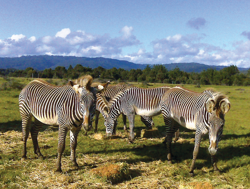
Go on safari in Mendocino County at the B. Bryan Preserve! Established by Dr. Frank and Judy Mello in Point Arena in 2004, the preserve was designed to aid in the conservation of rare and endangered African antelopes, zebras and giraffes. The preserve has three species of antelope, two of zebra and one species of giraffe living on over 110 acres of land. All are endangered to critically endangered.
Visits are available by reservation only at 9:30am and 4:00pm (3:30pm November to February). On these one-and-a-half hour tours you will have the chance to see the preserve’s animals in a natural habitat, somewhat similar to the land in their native Africa. This is a unique opportunity to observe and learn about the different species’ personalities and watch them interact. The B. Bryan Preserve is a great vacation destination with fully furnished eco-friendly cottages that are available for lodging. Learn more about the preserve online, where you can read about the animals and the mission of the preserve. An educated public is one of the many steps needed to ensure the survival of these wonderful animals.
WHERE: 130 Riverside Dr., Point Arena
MORE INFO: 707-882-2297, BBryanPreserve.com
Schooner Gulch State Beach

Local lore has it that Schooner Gulch got its name back in the era of sailing ships when a mysterious schooner ran aground there at dusk one evening, only to have vanished without a trace by the following morning. Today, Schooner Gulch State Beach offers its visitors not only great fun and exciting activities, but also some of the most magnificent views anywhere. Spend the day here hiking, picnicking, fishing, sunbathing, surfing or windsurfing.
Just north of Schooner Gulch you’ll find Bowling Ball Beach, named after the numerous prehistoric spherical boulders that cover the beach and are visible only at low tide. Such formations grow in underwater environments when materials collect around a nucleus, and are shaped by water action as it moves them around.
WHERE: About 3 miles south of Point Arena, mile marker 11.41 (Schooner Gulch) offers the closest parking area. Look for a sign that says, “Park Facing South Only.” There are two trailheads, about 100 feet apart. The southern trailhead takes you through a dense forest for a short quarter-mile hike to Schooner Gulch Beach. The northern trail goes to Bowling Ball Beach, and gets somewhat steep. You’ll want to go at low tide, so be sure to check a tide table before setting out.
MORE INFO: 707-937-5804, www.parks.ca.gov/?page_id=446
Anchor Bay
& Fish Rock Beach

When Sunset magazine ran a feature called “Top 10 Beaches of the West” a few years ago, Anchor Bay came in at number 3, just behind ‘Aliomanu Beach in Kauai, Hawaii, and well ahead of beaches in Carmel, Santa Barbara and San Diego. Located in the heart of the Mendocino “banana belt,” the coastal village of Anchor Bay is warmer, with less fog and wind, than the surrounding areas. The seclusion of the bay, which is edged by the white sands of Fish Rock Beach and framed by majestic weathered bluffs, makes it popular with visitors and locals. Protected from the wind, the bay is a delightful place to fish, scuba dive, ocean kayak, surf, and boogie and skim board. It is also a great place for sea lion- and whale-watching, as well as beachcombing and tide-pooling.
The beautiful and secluded village of Anchor Bay, a little north of Gualala, has a rich and colorful history. Prior to the mid-19th century, the Pomo Indians were the only inhabitants of the area. Settlers began trickling in after 1844, when the Mexican government made a large land grant to a man by the name of Rafael Garcia. Garcia brought in cattle and the area became used for ranching. Loggers came to the area in 1870, and a wharf was constructed and used for lumber products, fishing and occasionally rum-running during the Prohibition days.
Today, visitors enjoy Anchor Bay for its privacy and pristine beaches. Services available in Anchor Bay include a small shopping village, restaurants, lodging and a campground nestled amid redwoods and ferns. Anchor Bay offers relaxation, natural beauty and a peaceful, tranquil environment for spending vacation time along Mendocino’s South Coast. visitors will find an old-fashioned village market that specializes in natural foods, a complete wine and beer emporium, restaurants and other businesses. Accommodations in Anchor Bay include individual vacation rental cottages and homes, pristine housekeeping cabins, bed and breakfast inns and a campground.
WHERE: Between Gualala and Point Arena.
MORE INFO: 800-778-5252, RedwoodCoastChamber.com
Gualala

Gualala sits at the dramatic convergence of rolling coastal hills, the Pacific Ocean and the Gualala River. The southern coastal gateway to Mendocino County, Gualala is a delightful resort area and a favorite whale-watching spot. Its name comes from the Pomo Indian name for the river, “ah kha wa la lee,” which means “where the water flows down.” People from out of town usually call it gwa-LA-la, but locals pronounce it wa-LA-la. Once a logging town, Gualala’s primary economic activity is now tourism. It also serves as a commercial center for the surrounding area. Gualala is an ideal spot for viewing the elusive “green flash” that can sometimes be seen for a second or two as the sun sinks into the ocean.
Gualala Point Regional Park
Open daily from dawn till dusk, Gualala Point Regional Park is popular with day hikers and picnickers, and even offers a beautiful setting for small weddings. This lovely park encompasses almost 200 acres of peaceful meadows, dramatic coastal forests and delightful sandy beaches. The Gualala River runs lazily through it, and offers limited seasonal fishing (check the local regulations). The park also has an intimate, well-maintained campground situated among the majestic redwood trees and adjacent to the river.
Gualala Point Regional Park offers 2.9 miles of coastal trail along bluffs, through meadows, and above the Gualala River. Gualala Point Beach is easily reached via a dirt trail or ADA accessible paved path, and in general the trails throughout the park are relatively flat. Dogs are permitted on a leash no longer than 6 feet in length, and must be licensed. There are picnic areas scattered throughout the park, some with barbecues, and restrooms with flush toilets. The park has an informative Visitors Center featuring exhibits that showcase the history of Northern California, turn of the century logging, and Native American displays.
WHERE: 1 mile south of Gualala on Hwy 1.
MORE INFO: 707-785-2377, camping reservations 707-565-2267,
Parks.SonomaCounty.ca.gov/Visit/Gualala-Point-Regional-Park